A Gridded Dataset for Groundwater Sustainability Restriction Policy Scenarios for the Contiguous U.S.
Three scenarios of “low”, “medium”, and “high” levels of restriction on groundwater are developed. This dataset includes likely groundwater sustainability restriction policies (GSPs) considering 2010 levels
Listed in Datasets
Additional materials available
Version 1.0 - published on 04 Jun 2023 doi:10.13019/AHZR-4843 - cite this
Licensed under these terms
Description
Data Items
Three scenarios of “low”, “medium”, and “high” levels of restriction on groundwater are developed. This dataset includes likely groundwater sustainability restriction policies (GSPs) considering 2010 levels of groundwater withdrawals in the United States. Groundwater sustainability is defined in a rather simplified way assuming the groundwater extraction should not exceed the average recharge rates. The data is provided in NetCDF, GeoTIFF, CSV, and HAR file formats.
Purpose
The study of groundwater sustainability impacts is important, especially in dry regions of the world where water is scarce. Climate change and human activities (over-pumping, contamination, and land use changes) threaten groundwater quality and quantity, causing the drying up of wells, reduction of water in streams and lakes, deterioration of water quality, increased pumping costs, and land subsidence (Bartolino & Cunningham, 2003). Moreover, once groundwater is polluted or depleted, it is very difficult to reverse it. However, the magnitude of a groundwater sustainability policy varies depending on hydrological processes. Therefore, it is essential to understand the magnitude of such groundwater sustainability policy. This dataset was developed to provide insights into the magnitude and the impacts of likely groundwater sustainability restriction policies (GSPs) for potential use in quantitative studies evaluating the agricultural and economic consequences of water policies in the long run.
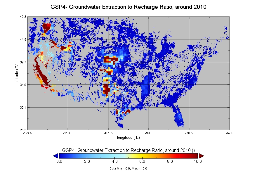
Methods are described in Haqiqi et al (2023). the ratio of groundwater extraction to recharge is calculated over cultivated Contiguous United States (CONUS) around the year 2010, based on average values from 2007 to 2013 for 5 arc-min grid cells. The calculation is based on three main gridded datasets for the United States including cultivated cropland, the share of irrigated area, and groundwater extraction and recharge rates. The cropland data is obtained from the United States Department of Agriculture Cropland Data Layer (CDL) at 30-meter resolution and is aggregated to 5 arc-min averages around the year 2010 (Baldos et al., 2020). The share of irrigated area is from Moderate Resolution Imaging Spectroradiometer (MODIS) Irrigated Agriculture Datasets for the Conterminous United States (MIrAD-US) averaged over 2007 and 2012 (Brown et al, 2019). And the data on groundwater recharge is from Reitz et al (2017) averaged over 2007-2013.
For agricultural and economic evaluation purposes, multiple groundwater sustainability policy scenarios (GSP) can be specified. Each GSP dictates a location-specific % reduction in groundwater extraction. GSP2 offers a very low restriction, assuming little to no intervention from local and federal governments but not allowing extraction of more than 2010 average levels (Baldos et al, 2020). This scenario assumes the depletion of groundwater continues but does not speed up. The GSP3 offers a middle-of-the-road scenario with more intervention but not achieving sustainable levels. This scenario attempts to lower the speed of depletion. The GSP4 scenario offers a close-to-sustainability scenario to keep the groundwater table at the 2010 levels (Ray et al, 2023). There is a GSP5 Scenario at the global level that offers a sustainability scenario considering the re-use of extracted groundwater (Haqiqi et al, 2022). The current dataset includes GSP2, GSP3, and GSP4.
Acknowledgements
We acknowledge support from the U.S. Department of Energy, Office of Science, Biological and Environmental Research Program, Earth and Environmental Systems Modeling, MultiSector Dynamics under Cooperative Agreement DE-SC0022141 (PCHES); the National Science Foundation HDR award # 2118329: "NSF Institute for Geospatial Understanding through an Integrative Discovery Environment (I-GUIDE); the United States Department of Agriculture AFRI Grant #2019-67023-29679: 'Economic Foundations of Long Run Agricultural Sustainability'.
References
Baldos, U.L.C., Haqiqi, I., Hertel, T.W., Horridge, M. and Liu, J., 2020. SIMPLE-G: A multiscale framework for integration of economic and biophysical determinants of sustainability. Environmental Modelling & Software, 133, p.104805, https://doi.org/10.1016/j.envsoft.2020.104805.
Bartolino, J. R., & Cunningham, W. L. (2003). Ground-water depletion across the nation. USGS Fact Sheet No. 103-03. https://doi.org/10.3133/fs10303
Brown, J.F., Howard, D.M., Shrestha, D., and Benedict, T.D., 2019, Moderate Resolution Imaging Spectroradiometer (MODIS) Irrigated Agriculture Datasets for the Conterminous United States (MIrAD-US): U.S. Geological Survey data release, https://doi.org/10.5066/P9NA3EO8.
Haqiqi, I., Bowling, L. C., Jame, S. A., Baldos, U. L., & Liu, J. Hertel, T. W., (2023). Global Drivers of Local Water Stresses and Global Responses to Local Water Policies in the United States. Environmental Research Letters. https://doi.org/10.1088/1748-9326/acd269
Haqiqi, I., Perry, C.J. and Hertel, T.W., 2022. When the virtual water runs out: local and global responses to addressing unsustainable groundwater consumption. Water International, 47(7), pp.1060-1084, https://doi.org/10.1080/02508060.2023.2131272.
Ray, S., Haqiqi, I., Hill, A. E., Taylor, J. E., & Hertel, T. W., 2023. Labor markets: A critical link between global-local shocks and their impact on agriculture. Environmental Research Letters. https://doi.org/10.1088/1748-9326/acb1c9.
Reitz, Meredith, Sanford, W.E., Senay, G.B., and Cazenas, Jeffrey, 2017, Annual estimates of recharge, quick-flow runoff, and ET for the contiguous US using empirical regression equations, 2000-2013: U.S. Geological Survey data release, https://doi.org/10.5066/F7PN93P0.
Content List
 Bundle(ZIP | 3 MB)
 A Gridded Dataset for Groundwater Sustainability Policy Scenarios_ v2.pdf(PDF | 431 KB)
- License terms
Cite this work
Researchers should cite this work as follows:
- Haqiqi, I. (2023). A Gridded Dataset for Groundwater Sustainability Restriction Policy Scenarios for the Contiguous U.S.. MyGeoHUB. doi:10.13019/AHZR-4843
Tags
Notes
GSP-2, 3 & 4 are released.