Close
GABBs is an NSF-funded project to create a powerful Web-based system that will allow researchers worldwide to manage, curate, share, analyze and visualize geospatial data for purposes ranging from predicting damaging floods to projecting climate change effects on the poor. The project builds geospatial data hosting, processing and sharing capabilities into Purdue’s HUBzero platform.

News


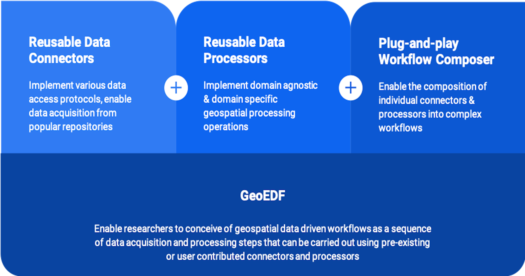
GeoEDF presented at the annual International Workshop on Science Gateways

Carol Song, PI of the NSF CSSI Framework GeoEDF project, presented the project design and outcomes, titled "A Framework for Designing and Executing Reproducible Geospatial Research Workflows in Science Gateways"  at the recently held International Workshop on Science Gateways, June...

Research Highlights

HydroGlobe

HydroGlobe provides hydrologists, educators and watershed managers instantaneous access to time series data for any watershed of interest. HydroGlobe takes care of the necessary data access, processing and aggregation behind the scenes.

StreamCI

StreamCI sensor data analysis cyber infrastructure aids sensor data researchers to easily collect, process, store, and access large volumes of heterogeneous sensor data collected in the field. Learn more about StreamCI (beta version) and start using it here.

Newsletter

Check out MyGeoHub newsletters which is published semi-annually to learn about the most recent development on MyGeoHub. The latest newsletter highlights StreamCI , a scalable and flexible sensor data platform that enables individual researchers to easily collect, process, store, and access large volumes of streaming data on the cloud.

Cultivista Crop Monitoring Tool

Crop Monitoring Tool (Cultivista) is an online tool that ingests monthly high-resolution satellite imagery (typically RapidEye or PlanetScope) for two regions in Peru, pre-process and classify those images based on a ground reference database, and then deliver summary diagnostics through a user interface.

AQP-Clima

Nexus Gestión Sostenible del Agua - AQP-Clima is a web tool that provides access to historical climate data for the Department of Arequipa, Peru. Here you can visualize, compare, and download annual, monthly, and daily climate data for any location within the department for use in many applications.

Advanced Cyber Training

The GeoEDF project enhances the course system HUBzero provides with dynamic data and tool functions and has been successfully used to develop multiple advanced cyber training courses, including FAIR Climate and Water Science, Short Course in Multi-scale Analysis of Sustainability, and more.

LeafSpec

LeafSpec provides georeferenced plant physiological information from data collected in the field using hand-held sensors.

iData

iData allows researchers to browse, discover, upload, share and publish their scientific data. The iData file browser supports metadata management, simple preview and scientific tool launch.

MultiSpec Online

MultiSpec is an image processing tool to display and analyze geospatial images that has been used by more than 600 researchers, teachers and students via MyGeoHub.org

GeoEDF1.0 Release

Release 1.0 of the GeoEDF workflow engine was deployed as a Conda environment/kernel in the Jupyter interactive computing environment on MyGeoHub. Find more details here

Data API

The data service API is used to enable field data collection from mobile devices and interoperability with other cyberinfrastructures.