MyGeoHub Training in Focus
MyGeoHub features a flexible and easy-to-use course facility to support teaching and learning in classrooms and self-paced studies from a browser. The instructors and students do not need to download or install any software. For instructors, the DIY-style course creation allows them to develop a course outline and fill it with learning materials and hands-on exercises, e.g., using interactive tools on MyGeoHub. For students, they can not only use the online course and resources to learn and practice but also stay on as a user to continue their research and learning after a class or training event.
As of July 2022, more than 1,000 users from approximately 150 schools worldwide, including K-12 and colleges, have used MyGeoHub in classes, training workshops, and self-paced learning.
A High School Class on MyGeoHub
In the Fall semester of 2021, MyGeoHub was used to support several classes taught by Mr. Nishimura at Toyama University of International Studies High School located in Toyama city, Toyama Prefecture, Japan. Around 120 students took Mr. Nishimura’s frontier class that teaches GIS and remote sensing skills using the interactive Multispec tool on MyGeoHub. Each class had 40 students who met twice a week. The students learned the basic knowledge of remote sensing and used the MultiSpec tool for hands-on practices, for example, to learn and visualize the difference of NDVI numerical values like water shed, bare land, botanic area and so on.

MultiSpec Online
Developed by Larry Biehl, MultiSpec Online is an open-source processing system for interactively analyzing Earth observational, multispectral image data such as that produced by the Landsat series of Earth satellites and hyperspectral image data from current and future airborne and spaceborne systems such as AVIRIS. It has found significant use in other applications such as multiband medical imagery and in K-12 and college level educational activities. Currently MultiSpec has several thousand known registered users, a significant uptake since MultiSpec was brought online from its desktop version.

FAIR CyberTraining (FACT) Fellows
We partnered with a CyberTraining team led by Drs. Merwade and Huber to train future researchers in making their research FAIR (Findable, Accessible, Interoperable & Reusable). Since 2020, the team has hosted and trained 10 FACT Fellows in climate and water sciences to use cyberinfrastructure and tools for their research. FACT Fellows are graduate students from universities across the U.S. They attended a virtual workshop using an online CyberTraining course developed and deployed on MyGeoHub, worked with their advisors and Purdue mentors to conduct research following the FAIR principles. The fellows used a mix of open-source tools in their FACT research to practice FAIR best practices, and created cyber training materials based on the work accomplished through this fellowship.
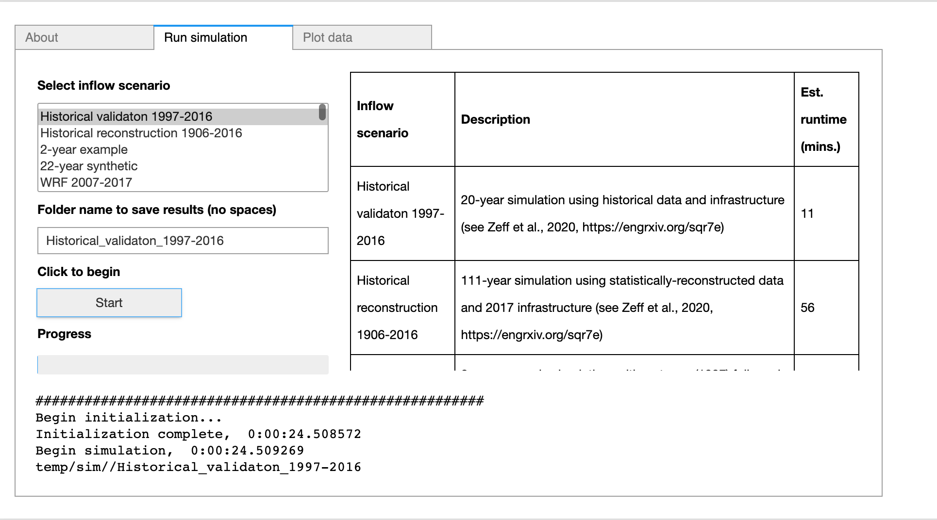
Andrew Hamilton, a 2020 fellow from University of North Carolina at Chapel Hill, published an online tool (screenshot above) on MyGeoHub for his CALFEWS model. CALFEWS is an open-source, Python-based model for simulating the integrated, multi-sector dynamics of water supply in the Central Valley of California. He also developed an online course titled “Python for Environmental Research” to introduce students to python programming through the lens of environmental research.