GABBs 1.0 Overview
CIF21 DIBBs: Integrating Geospatial Capabilities into HUBzero
This DIBBs implementation project develops geospatial data analysis building blocks (GABBs) to fill in a gap in the HUBzero Scientific Collaboration Platform to meet the needs for researchers and educators to create and share geospatial data sets and computational tools interactively on the web. The project builds upon open source geospatial software and tools that have been developed by IT experts and validated by the science community, and brings such capabilities to the masses so that non-GIS specialists can create and deploy online, interactive geospatial tools with open source software.
The project will produce GABBs software components, i.e., building blocks, as part of the future HUBzero open source releases and add-on packages. The deliverables include:
- Data management: easy-to-use tools and web services for users to self-manage, annotate, share, visualize and publish data, with special support for geospatial data (automatic metadata extraction, quick view, map layers, etc)
- Visualization: Extended Rappture Toolkit and map library Application Program Interfaces (APIs) to support rapid creation and deployment of GIS-enabled, interactive online tools
- Applications from scientific use cases of modeling, data analysis and visualization to demonstrate the general applicability of the GABBs software
- Public availability of GABBs software as downloadable virtual machines (VMs), Amazon Marketplace Instance (AMI), and packages through open source releases. Project results will be presented and published at scientific conferences, workshops proceedings and journals.
NSF Award number: #1261727 (award page)
Title: CIF21 DIBBs: Integrating Geospatial Capabilities into HUBzero
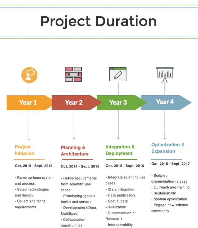
Project period: October 1, 2013 - September 30, 2017
Total award amount: $4.5M
Investigators:
- X. Carol Song, Rosen Center for Advanced Computing, Purdue University
- Larry Biehl, Rosen Center for Advanced Computing, Purdue University
- Venkatesh Merwade, Civil Engineering, Purdue University
- Nelson Villoria, Agriculture Economics, Purdue University
Team

Carol Song (PI and Project Director, Purdue University)

Carolyn Ellis (project manager, Purdue University)

Betsy Hillery (project manager, Purdue University)

Venkatesh Merwade (CoPI, Hydrology)

Nelson Villoria (CoPI, Agricultural Economics, Kansas State University)

Larry Biehl (CoPI, Image Processing, Geospatial Data)

Lan Zhao (Data Management/Processing, Geospatial Apps)

Leif Delgass (Geospatial Rendering, Hubzero)
Derrick Kearney (Rappture, Hubzero)
Rob Campbell (Data Components)

Rajesh Kalyanam (Data Services)

Hou-Jen Ko (Software Development)

Jaewoo Shin (Weather Application)

Adnan Rajib (Hydrologic Applications)

Michael Zentner (Hubzero Director)

Lui Zhu
Visiting Scholar
Dr. Eric Wei Wan
Student interns (2016)
Arjun Bagla, Computer Science, Purdue
- Integrating OPeNDAP with HUBzero (poster)
Ian Campbell, Computer Science, Purdue
- Developing the Geographical Data Explorer (GeoBuilder)
- Enhancing the Fine-scale Land Allocation Tool (FLAT)
Lingkun Ou, Electrical and Computer Engineering, Purdue
- Augmenting MultiSpec Software Infrastructure (poster)
Abilene Perez, Computer Graphics Technology, Purdue
- Usability Research on GeoBuilder (poster)
Bekmurat Spayev, Computer Science, Purdue
- Prototype of a mobile data collection application
Former Team Members
Mike McLennan (HUBzero lead. Now in Google Fiber)
George Howlet (Rappture, HUBzero)
Kevin Colby (Project manager)